
Fiùra:New York state geographic map-en.svg

Grannezza 'e sta PNG mostra 'e stu SVG file: 800 × 569 pixel. Ati resoluziune: 320 × 228 pixel | 640 × 455 pixel | 1 024 × 729 pixel | 1 280 × 911 pixel | 2 560 × 1 821 pixel | 2 811 × 2 000 pixel.
File 'e origgine (File SVG, dimenziune nommenale 2 811 × 2 000 pixel, dimenzione d' 'o file: 18,34 MB)
Riepilego
| Descrizione |
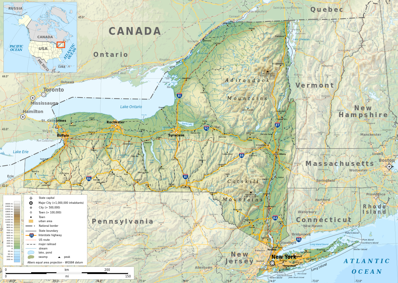
English: Geographic map of New York state in English. Geographic limits of the map:
|
| Data | |
| Funte |
Fatica propria
|
| Creatore | |
| Premmesse (Riausanno stu file) |
Any use of this map is subject of the license(s) stated below with the condition that you credit (Wikimedia Commons user: Ikonact) as the author . A message with a reply address would also be greatly appreciated. |
| Georeferencing | If inappropriate please set warp_status = skip to hide. |
|

|
This SVG file contains embedded text that can be translated into your language, using any capable SVG editor, text editor or the SVG Translate tool. For more information see: About translating SVG files. |
Licenza
| This work contains information from OpenStreetMap, which is made available under the Open Database License (ODbL).
The ODbL does not require any particular license for maps produced from ODbL data. Prior to 1 August 2020, map tiles produced by the OpenStreetMap Foundation were licensed under the CC-BY-SA-2.0 license. Maps produced by other people may be subject to other licences. |
Je, 'o titolare d' 'o copyright 'e sta fatica, dichiaro ca l'aggio pubbrecata sott' 'a seguente licienza ccà:
Questo file è disponibile in base alla licenza Creative Commons Attribuzione-Condividi allo stesso modo 4.0 Internazionale
- Vuje site libbero:
- pe spartere – pe' cupià, distribbuì e trasmettere 'a fatica
- p'ammescà – pe' putè adatta 'a fatica
- Sott' 'e cundiziune ccà abbascio:
- attribbuzione – Avite a dà criéreto, nu cullegamiento â licienza, e avite a dicere si nce avite cagnato quacche cosa. 'O pputite fà comme vulite, ma nun putite fà ntènnere ca chi tène 'a licienza ve sustene a vuje o â fatica vosta.
- sparte eguale – Si vuje cagnate, trasformate o fravecate coccosa ncopp'a sta fatica, allora avíte a distribbuì 'a fatica fatta cu 'a stessa licienza o na licienza cumpatibbele a chella origgenale.
Cronologgia d’’o file
Fa’ clic ncoppa a na data/ora pe vedé comme s'appresentava 'o file a chillo mumento.
| Data/Ora | Miniatura | Dimenzione | Utente | Commento | |
|---|---|---|---|---|---|
| attuale | 14:15, 2 Nuv 2023 | | 2 811 × 2 000 (18,34 MB) | Ikonact | corrected some typos in names // Editing SVG source code using c:User:Rillke/SVGedit.js |
| 12:22, 14 ott 2019 |  | 2 811 × 2 000 (18,41 MB) | Ikonact | better dealing with fall back font | |
| 23:19, 12 ott 2019 |  | 2 811 × 2 000 (20,53 MB) | Ikonact | + fall back font, more towns and islands, provinces | |
| 01:33, 12 ott 2019 |  | 2 811 × 2 000 (20,47 MB) | Ikonact | error corrected | |
| 01:23, 12 ott 2019 |  | 2 811 × 2 000 (20,47 MB) | Ikonact | river and lake names added | |
| 23:58, 8 ott 2019 |  | 2 811 × 2 000 (20,33 MB) | Ikonact | some improvements, roads and cities in Canada | |
| 09:40, 22 set 2019 |  | 2 811 × 2 000 (14,39 MB) | Ikonact | small corrections | |
| 22:49, 21 set 2019 |  | 2 811 × 2 000 (14,39 MB) | Ikonact | + road names | |
| 22:23, 21 set 2019 |  | 2 811 × 2 000 (14,31 MB) | Ikonact | +names | |
| 00:01, 21 set 2019 |  | 2 811 × 2 000 (15,37 MB) | Ikonact | == {{int:filedesc}} == {{Information |description={{en|1=Geographic map of New York state in English. Geographic limits of the map:}} *N: 45.30° N *S: 40.30° N *W: 80.20° W *E: 71.00° W Albers equal area projection; WGS 84 datum |date=2019-09-21 |source={{own}} *Sources of data:<br/> **Topography: ETOPO1 (public domain);<br/> **Public domain data provided by the National Atlas of the United States of America;<br/> *Tool:<br/> **The map is created with Octave scripts d... |
Jonte ê ffiure
Pe' nisciuna paggena ce buò stu file.
Auso globbale d’’o file
'E wiki ccà abbascio aúsano stu file:
- Uso ncopp'a af.wikipedia.org
- Uso ncopp'a ang.wikipedia.org
- Uso ncopp'a az.wikipedia.org
- Uso ncopp'a be.wikipedia.org
- Uso ncopp'a bg.wikipedia.org
- Uso ncopp'a bn.wikipedia.org
- Uso ncopp'a ca.wikipedia.org
- Uso ncopp'a en.wikipedia.org
- Uso ncopp'a eo.wikipedia.org
- Uso ncopp'a fr.wikipedia.org
- Uso ncopp'a ga.wikipedia.org
- Uso ncopp'a gl.wikipedia.org
- Uso ncopp'a ha.wikipedia.org
- Uso ncopp'a hu.wikipedia.org
- Uso ncopp'a hy.wikipedia.org
- Uso ncopp'a id.wikipedia.org
- Uso ncopp'a lt.wikipedia.org
- Uso ncopp'a mhr.wikipedia.org
- Uso ncopp'a ml.wikipedia.org
- Uso ncopp'a os.wikipedia.org
- Uso ncopp'a pcd.wikipedia.org
- Uso ncopp'a pl.wikipedia.org
- Uso ncopp'a sh.wikipedia.org
- Uso ncopp'a tg.wikipedia.org
- Uso ncopp'a tr.wikipedia.org
- Uso ncopp'a tt.wikipedia.org
- Uso ncopp'a uk.wikipedia.org
- Uso ncopp'a www.wikidata.org