
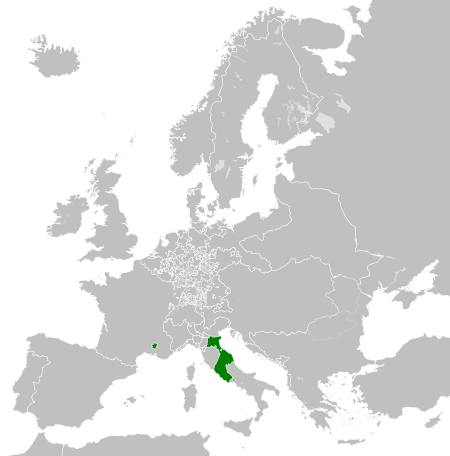
Fiùra:Papal States 1789.svg

Grannezza 'e sta PNG mostra 'e stu SVG file: 450 × 456 pixel. Ati resoluziune: 237 × 240 pixel | 474 × 480 pixel | 758 × 768 pixel | 1 011 × 1 024 pixel | 2 021 × 2 048 pixel.
File 'e origgine (File SVG, dimenziune nommenale 450 × 456 pixel, dimenzione d' 'o file: 799 KB)
Riepilego


.svg)
.svg)
.svg)
.svg)
.svg)


.svg)
.svg)
.svg)


.png)
.png)


.svg)


.svg)

.svg)


.svg)
.svg)
.svg)
.svg)


.svg)
.png)


.svg)


.svg)
.svg)


.svg)


.svg)


.svg)
.svg)
.svg)
.svg)
.svg)
.svg)
.svg)
_cropped.svg)
.svg)
.svg)
.svg)
.svg)
.svg)
.svg)
.svg)
.svg)
.svg)
.svg)
.svg)
.svg)
.svg)
.svg)
.svg)
.svg)
.svg)
.svg)
.svg)
.svg)
.svg)
.svg)
.svg)
.svg)
.svg)
.svg)
.svg)
.svg)
.svg)
.svg)
.svg)
.svg)
.svg)
.svg)
.svg)
.svg)
.svg)
.svg)
.svg)
.svg)
.svg)
.svg)
.svg)
.svg)
.svg)
Licenza
Je, 'o titolare d' 'o copyright 'e sta fatica, dichiaro ca l'aggio pubbrecata sott' 'a seguente licienza ccà:
Stu file è licenziato sott'a na licienza Creative Commons Attribution-Share Alike 3.0 Unported
- Vuje site libbero:
- pe spartere – pe' cupià, distribbuì e trasmettere 'a fatica
- p'ammescà – pe' putè adatta 'a fatica
- Sott' 'e cundiziune ccà abbascio:
- attribbuzione – Avite a dà criéreto, nu cullegamiento â licienza, e avite a dicere si nce avite cagnato quacche cosa. 'O pputite fà comme vulite, ma nun putite fà ntènnere ca chi tène 'a licienza ve sustene a vuje o â fatica vosta.
- sparte eguale – Si vuje cagnate, trasformate o fravecate coccosa ncopp'a sta fatica, allora avíte a distribbuì 'a fatica fatta cu 'a stessa licienza o na licienza cumpatibbele a chella origgenale.
Archivio 'e carreca origgenale
This image is a derivative work of the following images:
- File:Europe_1789.svg licensed with Cc-by-sa-3.0
- 2013-04-14T03:44:26Z Alphathon 450x456 (858577 Bytes) Corrected some errors in northern Italy
- 2013-04-14T01:38:01Z Alphathon 450x456 (853881 Bytes) tweaked again
- 2013-04-14T01:36:10Z Alphathon 450x456 (853881 Bytes) Tweaked Holy Roman Empire border style
- 2013-04-14T01:33:26Z Alphathon 450x456 (853857 Bytes) == {{int:filedesc}} == {{Information |Description={{en|A blank Map of Europe circa 1789. This map also includes a border for the [[:en:Holy Roman Empire|Holy Roman Empire]]. Since there are so many small German states, they h
Uploaded with derivativeFX
Cronologgia d’’o file
Fa’ clic ncoppa a na data/ora pe vedé comme s'appresentava 'o file a chillo mumento.
| Data/Ora | Miniatura | Dimenzione | Utente | Commento | |
|---|---|---|---|---|---|
| attuale | 09:58, 17 ott 2021 | | 450 × 456 (799 KB) | Fenn-O-maniC | Fixed the Russo-Swedish border to match the Treaty of Åbo of 1743 |
| 18:29, 18 Abb 2013 |  | 450 × 456 (820 KB) | Alphathon | Various fixes (see blank version) | |
| 06:00, 14 Abb 2013 |  | 450 × 456 (802 KB) | Alphathon | == {{int:filedesc}} == {{Information |Description={{en|A map the Papal States circa 1789.}}{{de|Eine Landkarte die Kirchenstaat c. 1989.}} |Source={{Derived from|Europe_1789.svg|display=50}} |Date=2013-04-14 03... |
Jonte ê ffiure
Pe' nisciuna paggena ce buò stu file.
Auso globbale d’’o file
'E wiki ccà abbascio aúsano stu file:
- Uso ncopp'a arz.wikipedia.org
- Uso ncopp'a ast.wikipedia.org
- Uso ncopp'a cdo.wikipedia.org
- Uso ncopp'a cs.wikipedia.org
- Uso ncopp'a en.wikipedia.org
- Uso ncopp'a fr.wikipedia.org
- Uso ncopp'a ga.wikipedia.org
- Uso ncopp'a gl.wikipedia.org
- Uso ncopp'a he.wikipedia.org
- Uso ncopp'a hr.wikipedia.org
- Uso ncopp'a ja.wikipedia.org
- Uso ncopp'a ka.wikipedia.org
- Uso ncopp'a ko.wikipedia.org
- Uso ncopp'a mk.wikipedia.org
- Uso ncopp'a oc.wikipedia.org
- Uso ncopp'a sq.wikipedia.org
- Uso ncopp'a tg.wikipedia.org
- Uso ncopp'a ur.wikipedia.org
- Uso ncopp'a www.wikidata.org
- Uso ncopp'a xmf.wikipedia.org
- Uso ncopp'a zh-min-nan.wikipedia.org
- Uso ncopp'a zh.wikipedia.org